Friday 21 January 2011

Kayaking is not a crime, but...

Thames Valley Police has reported the suspected involvement of a recovered kayak in a number of burglaries near the River Kennet in Reading:

"Thames Valley Police is trying to trace the owner of a kayak that has been found abandoned on the River Kennet in Reading.

The boat was found by a member of the public yesterday (20/1).

Police believe that the boat may be stolen and that it may have been used to transport goods stolen in recent burglaries in the Waterloo Meadows area.

PC Jon Hare, from the Burglary Team at Reading police station, said: “I am keen to hear from anyone who thinks that this kayak belongs to them.

“I am also keen to hear from anyone who has seen a kayak being used in suspicious circumstances on the Kennet recently.”

Anyone with any information about this boat should contact PC Hare via 0845 8 505 505.

Alternatively, if you do not want to speak to police, or leave your name, please contact the Crimestoppers charity on 0800 555 111."

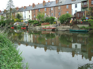
The River Kennet is fully canalised where it runs alongside Waterloo Meadows and on past the back gardens of Elgar Road houses.  Despite its proximity to the A33, this is normally a very peacefully stretch of the waterway after travelling down from Fobney Island and before reaching County Weir.  There aren't too many inner city paddles where you can pass by places like this, which might explain the popularity of canoeing and kayaking with local residents.

Just downstream of Waterloo Meadows, locals recognise the River Kennet as a great location for easy canoe and kayak paddling.

Friday 7 January 2011

Fobney Island "paradise" on hold

Plans to turn the somewhat dilapidated and artificial area of Fobney Island into a wetland "paradise", with dedicated bird watching and angling facilities, have apparently hit the harsh reality of the British economy, but the opportunity to include a sedate canoeing and kayaking channel at this River Kennet location appears to have never been considered.

Reading District Council (RDC) have admirably championed the regeneration of Fobney Island for a number of years, with the hope of transforming the site into a more readily accessible 'natural oasis' for the local population to enjoy on the western edge of the town.

Looking west across Fobney Island from the bottom of the site near the old pumping station at SU 705 710, close to the access bridge and proposed car park.  The tree line across the meadow marks the far bank of the c.825m riverine detour. 

Paddlers can currently park alongside the anglers' cars in the heavily pitted and often deeply puddled free parking just before the bridge over the Kennet at the end of Island Road, a sharp right turn just before the signposted recycling centre site which is approached by taking the second exit off the northbound A339 after passing the Madjeski Stadium.

In November 2007 getreading reported the initial outline plans for the re-development of Fobney Island.

Most paddlers on the Kennet Navigation at this point downstream on the lower reach are just concerned with how to portage the lock (nothing against racing - read this for an inspiring account of what people will do for others - but it's not every paddler's ideal way to spend time on the water; visit Marsport if it is). However, little consideration is given to the current riverine detour, because, frankly, after getting round the un-runnable weir the watercourse is a little dull once past the weir pool, and both can be flooded with fisherfolk.

The weir just beyond the divergence of the old river stretch from the Kennet Navigation cut is somewhat less than paddler friendly...

...but can be accessed by taking out between the divergence, crossing the bridge, and putting in easily in the weir pool river right.

The weir pool area is pleasant enough (mid-summer 2010), but soon straightens out along a less interesting stretch down to the bridge where the Navigation is rejoined.

Further development plans were trumpeted in 2009 by the Thames River Restoration Trust.

Sorry, low definition image. The first RDC/Environment Agency (EA) Fobney Island plans were overly ambitious in scope, and they blatantly ignored the ambition towards wider social inclusion defined in the pretended concept of "Restoration For All"

TRRT stated at that time that funding for this project was to come from RBC (£300k), the EA (£200k), TRRT (£150k) and Thames Water (£100k).  Whilst Reading and District Anglers Association (RDAA) and the Berkshire Ornithological Club were also named as partners in the project, there appears to have been no input on the part of recreational paddlers by the BCU.

It should be recognised that as one of the major 'sponsors' of this project, the TRRT (formerly the Thames Salmon Trust, until it renamed itself after it became increasingly obvious that the millions of pounds of public money spent in the name of this objective was failing), are clearly an angling interest group intent on securing more public money for the benefit of their congregation. Although currently undertaking a period of self-imposed transportation to Australia, TRRT trustee Martin Salter is a long standing objector to paddlers' navigation rights.

In June 2010 scaled back final plans were announced with the reported intention to begin work the following September and complete the Fobney Island Habitat Improvement Scheme in 2011. 

Posts marking groundworking locations were initially placed at Fobney Island in the summer of 2010 (one of my more exciting pictures from last year).

However, this week getreading updated on the current position, reporting that, as funding sufficient to complete the project in a single 17 week operation still hasn't be secured, the work may now be split into separate phases over two years.

It is to be hoped that the plans to turn Fobney Island into a nature reserve will eventually proceed despite the current economic climate, even if recreational canoeing and kayaking on the River Kennet will not be enhanced by this redevelopment.

And finally, whilst on the subject of Fobney Island, the idea that the old pumping station could be converted to a visitor centre is a further welcome suggestion, especially if it were to include some toilets and a picnic area with rubbish bins.

Local fishermen have complained about rats and "chafs" [sic] in the area of Fobney Island.

The low-rent carpet underlay picnic matting (which has 'fortunately' now been dumped by the car parking area) probably attracts them (the "chafs" that is),...

...whilst the low-rent picnic diet is probably what's causing the "chafs" loose bowels (and attracts the rats).

Sandwiches also disagree with the "chafs" delicate intestines, but at least they carry toilet roll with them (be grateful that the sunny day 'bleached' the white in this picture).

Sunday 2 January 2011

Access to the riverine Kennet loop at Southcote

New signs have been installed at Southcote Weir in an attempt to dissuade paddlers from navigation of the River Kennet.

The CEMEX Angling sign (click on the image to enlarge it) next to the sign-posted public footpath, proclaiming ownership of the fishing rights along the 1km riverine loop below the Southcote Weir in 2009...

...and the sign with a small addition at the start of 2011.

However, a public footpath runs alongside the right bank (see map below), providing easy access for much of the length of this run (see the original guide here, scrolling down to Southcote). 

Remember that CEMEX only owns the fishing rights, not the water.

[Image produced from Ordnance Survey's Get-a-map service. Image reproduced with permission of Ordnance Survey and Ordnance Survey of Northern Ireland.]

Note that the left bank does not have any public access rights, but it does have more signs.