As previously explained, for paddling purposes Newbury is regarded as the start of the lower reach, with the middle reach ending at SU 462 670, just to the west of the town, where the River Kennet rejoins the canal.
Newbury offers a range of paddling options beyond racing on the canalised sections, and it is a shame that the local authorities (who, at least in terms of parking near the navigation, appear to be positive in their approach to public access) haven't developed the existing watercourses more to exploit the business potential to the benefit of the town. In the interim to such enlightenment, there are several short runs that can be linked to traverse Newbury.

Northcroft Weir to Newbury Lock
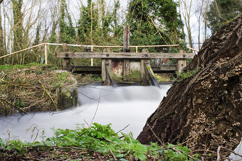
Just a few meters before the river rejoins the canal, Northcroft Weir and fish ladder can be found on the left. The electronically controlled weir is not shootable due to the low level steel footbridge overhead, but it is possible to put in to the weir pool below (see the four following images).
Please note the warning about the stopper in the UKRGB notes for paddling in Newbury


From the left of the weir, and...

...from the right of the weir.


An alternative view at low late summer water levels. Only a week or so after this picture was taken the weir was stopped completely with only the fish ladder feeding the stream.
You can then travel for approximately 900m down towards the centre of Newbury just below Newbury Lock.

This section is relatively easy to access river left from Northcroft recreation ground until the footbridge is reached. After that there are no good take-outs until you reach the land at the bottom of Northcroft pay-and-display car park, river left.
At SU 467 671 a sluiced outflow from the canal enters the river on the right. The river then bends around The Old Mill, and there is a potentially dangerous pipe which crosses the flow here (again please note the warning in the UKRGB description of this location - see above for a link).

An old pipe crosses the river supported by a small concrete island. The spiked steel fence was presumably erected to stop people traversing the pipe, but both would probably be candidates for removal/relocation if the river was used to it's full potential.

The pipe is supported by a girder right of the 'island', and can be limboed under at low levels...

...like this, or...

Below this point is a pool formed where another outflow from the canal passes under the road at Dolton Mews, again entering the river from the right.

Below Dolton Mews the river continues down past old slalom poles that attest to paddling on this stretch in the not-too-distant past, and on under a footbridge that passes alongside the Lock Stock and Barrel pub over to Lock Island, to rejoin the canal.

The river continues down past private residences on the left and Lock Island on the right before rejoining the canal.
Parking for access to this section is available at the public pay-and-display car park at Northcroft Lane West (just before Northcroft Recreation Centre) [SU 467 672]. Charges as of 6 April 2009: Monday to Saturday up to 2 hrs = £1.20, up to 4 hrs = £2.40, over 4 hrs = £4.00, evening charge after 18:00 = £1.00. A map of West Berkshire Council parking in Newbury is located here.

The weir is just visible to the right of the residential properties on the site of the former Town Mill at West Mills.


The weir can be shot down the slope from the left of the sluices.
...down a slope to where the river flows straight into a wall and is channelled left. There is no good egress opportunity up the vertical steel shuttered embankment below the private housing of Town Mills, so if you swim on this one you'll need to quickly get over to the bank (and landing stage) on the island to the left that separates the flow from the canal. Failing to do so will mean, as a minimum, an embarassing float past the Lock Stock and Barrel pub, and on past the other canalside bars and barges in the middle of Newbury. A description of the weir as a playspot can be found on the UK Rivers Guide Book here.

Below Newbury Weir...

...with the river channelled left at the bottom of the weir.


Returning to the canal from the weir.
.jpg)
Looking downstream towards Newbury Bridge.

Looking back upstream from below Newbury Bridge.

Looking downstream from the left bank between Newbury Bridge and Parkway bridge.

A339 to Greenham Lock via the southern river course
[this section has not been paddled by the author of this blog]
The River Kennet forks to the right away from the canal just downstream of the A339 road bridge, at the back of the police station and county courts. It flows for less than 300m until it reaches the site of the former Greenham Mill. Three floating barrages protect the weir from any large debris, but, whilst they could possibly be crossed by paddlers, it would be sensible to portage at this point.

Approaching Greenham Mill weir. Potential to get out on your right or just paddle back upstream to the canal.

Looking back upstream to the barrages above Greenham Mill, with the start of the fish ladder river left.
Taking out above the fish ladder river left would mean climbing up onto a small strip of grass right in front of a living room window, whilst taking out on the fish ladder would bring you dangerously close to the weir, so for the sake of discretion and safety it would be easier to take out river right and walk across the footbridge over the sluice.

Greenham Weir and fish ladder.
Don't be tempted to limbo under the bridge to the right, where the spill pool passes the weir, with the thought of seal launching after the weir. Immediately to the left after the weir the river is channelled through a small unbarred opening and away under garages and the road on to the mill island, whilst the channel that flows straight ahead is restricted in width before it flows under the low road bridge.

Downstream of Greenham Weir.


Looking back upstream to Greenham Weir from the road bridge onto Greenham Mill.
If you've paddled down from Newbury Lock, exit the canal on the left just before the road bridge and follow the footpath underneath to just past the sluice. Alternatively you can park in the car park of Newbury FC at SU 474 672 and walk across the grassed area to the stream.

It is not necessarily the cleanest of locations (late September '09).

The northern 'Newbury bypass stream' at a reasonable water level with gates open (note the immersion of the pointed rock in front of the square buttress) ...

...and with the gates closed down to trickle at the end of September '09.

Below the sluiced outflow old bicyces and shopping trolleys are revealed at low water levels (and are therefore worth remembering if you paddle this at higher levels).
The stream flows past Newbury FC with a footpath on the left (until a high wooden footbridge is reached - the public benches river right just above the bridge seem to be a popular point to throw beer bottles into the water), and the canal towpath to the right for 400m. At SU 478 673 there is a weir outflow from the canal and the stream turns sharply left before curving around and past the canal boat marina on the right for another 230m. At this point it rejoins the canal just below Greenham Lock.

Looking upstream from the weir bridge in winter...

 Looking downstream from the canal towpath as it crosses the weir...


The new and improved Bone Mill sluice shortly after refurbishment at the end of 2008 (it used to look like this). 
The river proper separates from the canal at Ham Mill [SU 486 672], but this structure and a sluice weir bars the flow (a recurrent feature on the River Kennet, as will be seen in subsequent posts).


...and at the end of April.


...no way through for paddlers.


...and also just a few meters further down the canal. The river flows away from the canal before it reaches Ham Bridge.

Looking back across the canal from the strip of land between the canal and the river...

...and over to the outflow below Ham Mill weir.


The River Lambourn is not a viable route of access to the River Kennet.

From the driveway into Newbury Manor Hotel.
From below Ham Lock the river flows unimpeded (except by fallen trees).

The River Lambourn joins the Kennet river left at the edge of Newbury Manor Hotel.

Looking downstream from the bank river right between Ham Mill and Ham Bridge

Upstream from the B3421 road bridge...


...but overgrown by the end of April.

.jpg)

...whilst there are two gates and three signs to the river right, just to make the point.
.jpg)
From SU 470 671, where the river stream joins the canal, you can cross the canal and paddle back upstream past Town Mills to a weir.


Looking back upstream from Newbury Bridge, the river rejoins the canal from under the white footbridge to the right of the picture, Newbury Lock is in the center, and the channel to the left leads down from the weir above the lock. This aspect only came into being after Newbury Lock Cottage burnt down in 1989 and the area was created as a public space in 1995. Before the fire the view was like this.

The weir is just visible to the right of the residential properties on the site of the former Town Mill at West Mills.
Where the canal spills over above Newbury Lock. The right half of the structure is controlled by board-protected sluice gates, whilst the left half is an open drop...

Above Newbury Weir, looking across the canal towards Town Mills.

The weir can be shot down the slope from the left of the sluices.
...down a slope to where the river flows straight into a wall and is channelled left. There is no good egress opportunity up the vertical steel shuttered embankment below the private housing of Town Mills, so if you swim on this one you'll need to quickly get over to the bank (and landing stage) on the island to the left that separates the flow from the canal. Failing to do so will mean, as a minimum, an embarassing float past the Lock Stock and Barrel pub, and on past the other canalside bars and barges in the middle of Newbury. A description of the weir as a playspot can be found on the UK Rivers Guide Book here.

Below Newbury Weir...

...with the river channelled left at the bottom of the weir.

At really low levels there's not much to play with.

Returning to the canal from the weir.
From Newbury Lock to the next River Kennet detour just past the A339 road bridge it is necessary to first travel east on the canal for about 500m, under Newbury Bridge and Parkway bridge, and alongside the pay-and-display car park at Newbury Wharf on your right (click here to open a document of parking charges applicable from 2009), which is a potential put-in/take-out point (don't try to squeeze in on the Waterside series race days). There are usually a lot of swans on the canal here as that's where they're fed by the public.
.jpg)
Looking downstream towards Newbury Bridge.

Looking back upstream from below Newbury Bridge.

Looking downstream from the left bank between Newbury Bridge and Parkway bridge.

Swans on the Kennet Navigation opposite Newbury Wharf. The get out for the next section is just before the A339 road bridge, river left.
[this section has not been paddled by the author of this blog]
The River Kennet forks to the right away from the canal just downstream of the A339 road bridge, at the back of the police station and county courts. It flows for less than 300m until it reaches the site of the former Greenham Mill. Three floating barrages protect the weir from any large debris, but, whilst they could possibly be crossed by paddlers, it would be sensible to portage at this point.

Approaching Greenham Mill weir. Potential to get out on your right or just paddle back upstream to the canal.

Looking back upstream to the barrages above Greenham Mill, with the start of the fish ladder river left.
Taking out above the fish ladder river left would mean climbing up onto a small strip of grass right in front of a living room window, whilst taking out on the fish ladder would bring you dangerously close to the weir, so for the sake of discretion and safety it would be easier to take out river right and walk across the footbridge over the sluice.

Greenham Weir and fish ladder.
Don't be tempted to limbo under the bridge to the right, where the spill pool passes the weir, with the thought of seal launching after the weir. Immediately to the left after the weir the river is channelled through a small unbarred opening and away under garages and the road on to the mill island, whilst the channel that flows straight ahead is restricted in width before it flows under the low road bridge.


...not a sensible choice unless you're a cave diver.

Looking back upstream to Greenham Weir from the road bridge onto Greenham Mill.
The river continues as a rather shallow, tree strewn, and delapidated affair beyond the road bridge, and having had to get out above the weir, it would therefore be more sensible to run the wider parallel course that runs out from under the Greenham Mill site andover a small double weir by putting in from Gould Close, where it is possible to park alongside the river bank. From here it is just a short paddle of 180m to the canal below Greenham Lock
A339 to Greenham Lock via the northern stream course
[this section has not been paddled by the author of this blog]
Given the difficulties associated with the southern route of the Kennet, an alternative run is available. Immediately below the A339 bridge there is a sluice to the left of the canal that initiates a fast flowing winter water level stream. In summer or autumn low flows you might prefer to stay on the canal. See the UKRGB guide linked above for this sluice.
If you've paddled down from Newbury Lock, exit the canal on the left just before the road bridge and follow the footpath underneath to just past the sluice. Alternatively you can park in the car park of Newbury FC at SU 474 672 and walk across the grassed area to the stream.

It is not necessarily the cleanest of locations (late September '09).

The northern 'Newbury bypass stream' at a reasonable water level with gates open (note the immersion of the pointed rock in front of the square buttress) ...

...and with the gates closed down to trickle at the end of September '09.

Below the sluiced outflow old bicyces and shopping trolleys are revealed at low water levels (and are therefore worth remembering if you paddle this at higher levels).
The stream flows past Newbury FC with a footpath on the left (until a high wooden footbridge is reached - the public benches river right just above the bridge seem to be a popular point to throw beer bottles into the water), and the canal towpath to the right for 400m. At SU 478 673 there is a weir outflow from the canal and the stream turns sharply left before curving around and past the canal boat marina on the right for another 230m. At this point it rejoins the canal just below Greenham Lock.


...it can be quite heavily overgrown in summer.
Looking downstream from the canal towpath as it crosses the weir...
...the river swings right past a marina and narrowboat repair facility, before passing under the white bridge and rejoining the canal below Greenham Lock. I was manfully hiding from an aggressive swan when this image was taken.
Greenham Lock to Bulls Lock
[this section has only been paddled along limited short lengths by the author of this blog]
[this section has only been paddled along limited short lengths by the author of this blog]
Below Greenham Lock it is necessary to paddle the canal for 500m before reaching Bone Mill sluice, and a further 400m to the point where you can portage across to the river beyond Ham Mill.
Before you get there, there is a potential put-in/take out beyond Greenham Lock on the left at the bottom of The Narrowboat pub car park [SU 483 673]. The landlord was perfectly agreeable when permission was asked to leave the car and launch from here - he even talked of getting himself an inflatable kayak! Don't forget to have a pint or eat here if using the car park (very family orientated, and I saw KT Tunstall play here in 2005, so it must be good!).
At Bone Mill sluice the Environment Agency completed renovation of this structure in December 2008/January 2009 with the result that there is only a low flow out from the canal, and the ensuing stream run off is so shallow as to be almost unpaddleable over its 600m course alongside the canal. This does, however, appear to have been a necessary refurbishment to the flood channel gates - see here and here - but there is a more interesting potential alternative route forward down the river.

The new and improved Bone Mill sluice shortly after refurbishment at the end of 2008 (it used to look like this).

The flow had improved by April 2009...

...but not enough to make this an interesting or even useful side run. A potential opportunity for a paddlesport training course wasted perhaps?
.jpg)
The overflow stream from Bone Mill sluice rejoins the canal at Ham Bridge. The concrete bar can be overcome by high/flood water, whilst the normal trickle is channeled off by a drain just after the footbridge, which then flows along the back of the industrial units to rejoin the canal below Bulls Lock.
The river proper separates from the canal at Ham Mill [SU 486 672], but this structure and a sluice weir bars the flow (a recurrent feature on the River Kennet, as will be seen in subsequent posts).

Approaching Ham Mill (right) and Ham Lock in winter...

...and at the end of April.

Ham Mill and sluices to the right...

...no way through for paddlers.
By portaging around Ham Lock on the canal it may be possible to get out to the left and cross through the trees back to the river just below where an offshoot of the River Lambourn enters from the right.

The river below Ham Mill sluices can just be seen through the trees on the left of the canal below Ham Lock...

...and also just a few meters further down the canal. The river flows away from the canal before it reaches Ham Bridge.

Looking back across the canal from the strip of land between the canal and the river...

...and over to the outflow below Ham Mill weir.

Below the weir pool the river can become quite shallow during the summer.
Don't bother trying to circumvent Ham Lock by getting on the River Lambourn and paddling down to the confluence of this tributary with the Kennet because the bridge where the river enters the Newbury Manor Hotel after crossing under the A4 is too low, and there are further weirs and bars even if you were permitted to launch from the hotel grounds.

The River Lambourn is not a viable route of access to the River Kennet.

From the driveway into Newbury Manor Hotel.
From below Ham Lock the river flows unimpeded (except by fallen trees).

The River Lambourn joins the Kennet river left at the edge of Newbury Manor Hotel.

Looking downstream from the bank river right between Ham Mill and Ham Bridge
After just a short run it flows under to the bridge carrying the B3421 Hambridge Lane (south of the A4 at SU 490 672)...

Upstream from the B3421 road bridge...

...and downstream from the bridge, with the water gauge (river right) visible in winter...

...but overgrown by the end of April.
...where it would be possible to take-out/put-in immediately downstream river right.

There is roadside access to the River Kennet from the B3421 bridge, but there is no adjacent public parking.
Other than this there is no access to the banks which are all fenced off and marked as private property.
Other than this there is no access to the banks which are all fenced off and marked as private property.
.jpg)
The banks are barred to public access river left below Ham Bridge...

...whilst there are two gates and three signs to the river right, just to make the point.
Approximately 1.5km from Ham Lock is the take-out/put-in near Bulls Lock at SU 498 666. From here, section 2 starts.
.jpg)
One of the potential take-outs above Bull's Lock.


