Tuesday 29 June 2010

River Kennet restoration near Hungerford

One of the largest restoration projects on the upper Kennet was completed between October 2009 and March 2010, when the hydromorphology of a 2km stretch of the river downstream of Denford was extensively remodelled in 11 sections by Cain Bio-Engineering Ltd., funded by the Environment Agency and Natural England.  A case study from the contractor can be found here.

Starting at the first section, a stroll downstream between the river and the canal at The Gatehouse, just to the east of Hungerford where the River Dun joins a branch of the River Kennet at SU 352 682, demonstrates some of the remedial river engineering techniques that have been applied, but just in case you thought it might be a worth having a closer look at this relaxing and beautiful place by means of a gentle summer paddle...

New fencing, but the same old sign.  Access rights are restricted by antiquated 'laws' that uniquely protect the rights of "commoners" over the general public (this will be the subject of  future post)...

...but the swans don't care.

At the end of June 2010 it was still possible to identify man's hand (or at least his vehicle's tracks) in the restoration process.

Ranunculus growth is the sign of a healthy chalk stream; more would always be welcome.  The new fencing is to protect the banks from erosion during periods of grazing by "commoners".


Scarlet Tiger moths inhabit the edge of the river in the early evening sunshine.
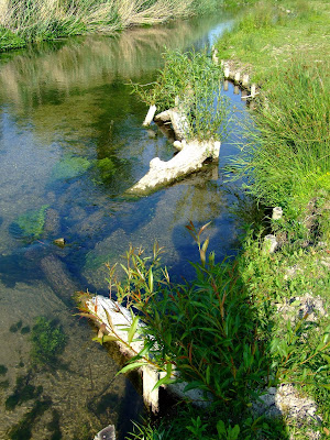

Narrowing of the channel with bank reinforcement has increased the flow rate and, together with such as the deposition of large woody debris (LWD) with combined in-stream willow growth, it is clearing silt and algae from the bottom to leave 'gin-clear' water in which trout are readily spotted (this is probably not such a good thing if you are a trout, but I'm sure they appreciate the improved water quality).
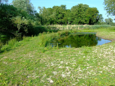

Flood overflow pools help maintain the margins...

...but just after you pass this sign (to remind you who's paying for all the work) by the style over the fencing...

...you reach this bridge and the start of the Avington Estate.

From this point your view of the further sections of the restored River Kennet depend on your eyesight.

I have no complaint that money is being spent on restoring the quality of a classic chalk stream river before it is destroyed (and the EU rubs salt in the wound of our loss by fining the UK for the neglected state of our waterways).  

The bit that sticks in the throat here is simply that the majority of the restoration works are inaccessible to the public who have paid for them via taxation from which the EA and NE is funded.  Whilst, in the broadest general sense, we all benefit from the revitalisation of our chalk stream rivers, and it is not questioned that this section of the Kennet appears to have been substantively improved by these innovative works, private fisheries are effectively receiving direct economic benefit from those they exclude.  If you think this is possibly iniquitous, you might also want to note that the contractor, Cain Bio-Engineering, is a founding member of the Wild Trout Trust.

On-line river level guide for the River Kennet

The launch of the Environment Agency's on-line river level reporting service for England and Wales, which makes use of the national network of gauging stations to augment flood warnings, also offers paddlers planning to travel to the River Kennet the opportunity to remotely view current conditions before leaving home. 
The Kennet gauges are located at
  • Winterbourne Monkton on the upper Upper reach
  • Marlborough on the Upper reach   
  • Knighton - two gauges on the Upper reach between Ramsbury and Chilton Foliat
  • Eddington at Hungerford where the Middle reach starts
  • Newbury on the Lower reach
  • Theale (Barble Bar) on the Lower reach 
  • Blakes Lock, Reading on the Lower reach not far from The Thames confluence.
There are a further 12 gauges reporting the flow for the Kennet tributaries of the Og, the Aldbourne, the Dun, the Shalbourne, the Lambourn, the Winterbourne, Kingsclere Brook, the Enborne, and the Foudry Brook.

However, only the last three of the main River Kennet gauges are of much use to paddlers, in that they are located on sections of the river where paddling is generally viable, and only Theale gives a good river level indication in terms of partial independence from the water of the canalised Navigation.

The Theale gauge currently shows the river to be significantly low within a bandwidth of typical range, but, hey, it's summer and it hasn't rained much recently.

The Kennet with low water levels at the Theale gauging station at the end of June 2010, but Barble Bar is still going.

Saturday 26 June 2010

Plus ça change, plus c'est la même chose

Another post on public access to "our natural heritage", with some reflections on recently promised political change and the reality of vested interests preserving the status quo...
...if you'd rather just get on with your canoeing and kayaking on the River Kennet please disregard the following text ;-).  If you have any concern about the continuing attempted infringement of your rights, read on...

Before the 2010 UK General Election:

On the 28 April 2010 The Telegraph's Environment Correspondent Louise Gray reported online under a heading of "Lib Dem plans for the environment" , that "Greenpeace have described the Lib Dems plans for the environment as the most ambitious of any party."

Within a summary of Lib Dem policies, her article noted a position that would provide a "Full access code for the countryside. Everyone will have statutory access rights to most land and inland water – as long as they follow responsibility law.”

This opinion may well have been based on the tone, if not the implicit statement, of  section 4.1.2 of Lib Dem Policy Paper 93 from July 2009, titled "Our Natural Heritage: Policies on the Natural Environment".  At the time of writing it remains available for public view here

Note the proud claim in Policy Paper 93 that Scottish Lib Dems had been instrumental in introducing the "Land Reform (Scotland) Act 2003   [...] establishing a statutory right of responsible access to land and inland waters for outdoor recreation, crossing land and some educational and commercial purposes."

At grassroots level it was clearly perceived that Lib Dems would promote such a policy in England and Wales, as reported in this blog's post of 16 April 2010.

However, by the eve of the General Election any pretense to such aspirations had been dropped, at least by the higher echelons of the Lib Dems, when, together with the Conservative and Labour parties, they signed up to The Angling Trust's "Angling Manifesto" [click on the document link at the bottom of the Angling Trust web page to read a copy].

With a clear statement of Angling Trust policy to actively seek limitation on non-angling users of our waterways signalled by the phrase "voluntary access agreements are the only way to manage an increase in water based recreation on inland waters", it was unsurprising to see that it was Huw Irranca-Davies who confirmed the Labour government's stance of the previous 13+ years, and almost inevitable that it was Richard Benyon who, in possibly confident expectation, set forth the Conservative statement of continuing alliance with a particular interest group over the wider population.

After the 2010 UK General Election:

In the brief political interregnum during the formation of the current coalition government it would appear that an 'understanding' of this position of limitation was confirmed on the issues of river access and navigation rights for the English and Welsh electorate.

On the 12 May 2010 Telegraph Political Correspondent Rosa Prince was one amongst many when she reported "In a historic press conference in the Downing Street garden, the Prime Minister and his new Deputy Prime Minister committed themselves to 'three key principles' of 'freedom, fairness and responsibility'."

These principles were clearly not intended to include paddlers, and by the end of the following day BBC News Environment analyst Roger Harrabin had written "And what of the Liberal Democrat manifesto promise of a broader right for people to roam in the countryside in the Scandinavian fashion? There is no mention of that in the joint statement and it may be that Conservative landowners have barred the gate."

The 14 May 2010 saw confirmation of Richard Benyon as a Parliamentary Under-Secretary for Natural Environment and Fisheries at DEFRA.  His responsibilities include inland waterways (including British Waterways), coastal and wider access, countryside and rights of way.

On the 16 May 2010 Nick Clegg stated that "Real, big change never comes easy.  So it would simply be wrong for us to let this chance of real change pass us by.  [...] the chance to hardwire fairness into our society, the chance to change Britain for good."  Hollow words.

As for the news from Wales, the position of the National Assembly on navigation and access to rivers has changed over the last year from this to this, and their final report into "Access to Inland Water in Wales" doesn't really deserve further comment other than to say another sell out.