Sunday 20 November 2011

Kennet shutting down due to low later levels

Although the Kennet and Avon Canal is not normally the focus of this blog, it has a significant bearing on the Kennet Navigation and the riverine levels where it is a primary feeder source from just above Hamstead Lock.  With the closure of a long section of the K&A Canal last Thursday, it would seem likely that the lower reach of the River is now facing an indefinate extension or even exacerbation of the low water levels currently evidenced. 
The British Waterways announcement stated:

"Stoppage: NAVIGATION CLOSED UNTIL FURTHER NOTICE LOCK 61 TO LOCK 80

17 Nov 2011 until further notice

The canal has been closed to navigation between Crofton Lock 61 and Copse Lock 80 due to lack of adequate water supplies to support boat movement.

All of the locks within the closed section will be padlocked to prevent use. We are allowing levels in individual canal pounds to recover slowly. Several sections are very low and will take some time to come back to normal level. This is a long term problem brought about by ground water level being extremely low, in fact it is at the lowest level for 90 years.

The reservoir level is also very low and currently has little or no feed to recharge the system. The current stoppage is necessary to recover levels and help protect aquatic life in the canal.

British Waterways is currently looking to support the closed section with additional water supply from other sources.

The current closure is being reviewed weekly, and with little or no significant rain forecast the current closure may remain in force for some weeks."

The CEH October hydrological summary had already identified the critical lack or rainfall, exceptionally low river flow and almost record breaking low level of groundwater reserves on the 11th Novenber, so with the River Kennet failing in its own right, the news from the canal was most unwelcome.

The view at Benham Weir from the bottom of the fish pass on Sunday 13 November 2011.

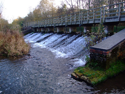
The footings of the weir buttresses would be covered for sufficient paddling levels, so whilst it would be possible to descend from the second space from the left as you approach the top of the weir...

...downstream paddling would probably be a scrape with the possibility of hitting spawning trout redds in current conditions.

Saturday 17 September 2011

Low level riverine Kennet conditions persist

Having been out of the UK for most of August I was frequently told on my return how miserable the weather had been.  However, the CEH Hydrological summary for August states that

"in parts of southern Britain flows in index rivers were notably low and accumulated runoff totals over the last six months are depressed in most central and southern catchments. In rainfall terms, the drought has substantially decreased in spatial extent since the spring but with the bulk of the summer rainfall accounted for by evaporation losses, a wet autumn is required to generate a sustained seasonal recovery in the depressed runoff and, particularly, recharge rates across the drought-affected areas."

It continues that "Some southern spring-fed rivers have registered 16 successive months with below average flows and further evidence of the decline in baseflows is provided by the early cessation of flows in some winterbournes (e.g. the Till in Wiltshire)."

The River Kennet proves the point well, and Barbel Bar is currently showing even lower levels than when last reported in June.
The Environment Agency's Kennet gauging station at Barbel Bar is currently showing a river level of 0.23m. The typical river level range for this location is between 0.23m and 0.83m.

I've also been meaning to try out Aldershot Water as a route to access the river between Chamberhouse Mill and Brimpton Mill (rather than walking down through the nettles along the footpath alongside this short watercourse), but that doesn't look like happening any time soon.

Aldershot Water where it enters the River Kennet, connecting from the Kennet Navigation...

...but current levels are not for paddlers who like the bottom of their boats.

Saturday 25 June 2011

Waterways Minister says no to statutory right of access for paddlers

On the 13 June 2011 MP Ian Austin (Dudley North, Labour) received the following response to his Parliamentary written question
 "To ask the Secretary of State for Environment, Food and Rural Affairs if she will consider the merits of introducing a statutory right of access for unpowered craft to inland water for recreational purposes."

Richard Benyon (Parliamentary Under Secretary of State (Natural Environment and Fisheries), Environment, Food and Rural Affairs; MP for Newbury, Conservative) replied that

"We have no plans to introduce a statutory right of access to inland water for unpowered craft for recreational purposes. We are keen to achieve far greater levels of access to waterways for canoeists and other users by encouraging locally agreed, voluntary, access agreements. This fits very well with the big society agenda as it will give access where it is needed and meet the needs of all users and interested parties."

Whilst it comes as no surprise that this Minister has reiterated his personal and party stance in this way, it serves to once again highlight  the facile emptiness of the Coalition Government's claim that it seeks to build a fairer society, and demonstrates that it is prepared to ignore the clear failure of this approach over previous years, and its own recent 'Red Card to Red Tape' recommendations to remediate this inequity, in order to protect the status quo in favour of vested interests.

Waterways Minister Richard Benyon disagrees with the report comissioned by the Minister for Sport and the Olympics, Hugh Robertson MP, which conludes that "DEFRA should introduce a statutory right of access in England and Wales for unpowered craft to inland water for recreational purposes.  This system of rights and responsibilities should be based on the Scottish Outdoor Access Code."

Sunday 19 June 2011

River Kennet chosen to highlight contested paddling access rights

Some images from last weekend's paddle on the River Kennet between Padworth Lane road bridge and Sheffield Bottom.  Thanks to Jennie, Joel and Mal for the pics.

With paddlers travelling from Bristol, Hampshire, Surrey, and West Sussex, the chosen meeting point was the Kennet & Avon Canal Visitor Center at Aldermaston Wharf(pedantically, it should really be called the Kennet Navigation Visitor Center this far downstream from Newbury, but who cares).  There are 15 parking places, and on the sunny day before (when this picture was taken), they were full.  By midday on the 12th the wet forecast had allowed everyone to park up without obstructing other visitors, and having already enjoyed breakfast (my wife was bribed into assistance on the day with the promise of a bacon and egg butty, which I wished I'd ordered too as I watched her enjoyment over my toast and coffee), the group moved down to the put-in.

With 8 vehicles turning up at the put in (including our volunteer shuttle driver who'd only learnt the route the day before), off-roadside parking for 2-3 vehicles can be made just before the bridge, whilst just over the bridge there is similar space for 4-5 vehicles considerately parked. A thank you goes to the landowner  who responded kindly to our request to park next to his gate.  The group gathered for a final briefing alongside the public footpath that runs river left between Padworth Mill and Padworth Lane.

The put in utilised an existing track and break in the plant growth for minimal disturbance.
The group of 11 paddlers (including one two year old - canoeing and kayaking is an inclusive, family orientated activity for all ages) assembled on the water...

...before the 6 canoes and 2 kayaks headed towards Padworth Lane road bridge.

Once beyond the bridge the group were now paddling through the Englefield Estate, home to DEFRA Waterways Minister Richard Benyon.  He had been contacted prior to the paddle for advice on any potential hazards or river works, and the communication had been forwarded to the Estate Office, who advised that there were no known obstructions on the route.

The section down from Padworth Lane is a prime fishing beat, and other than a half-submerged old rowing boat, is remarkably free of the litter and other human debris that so often blights such stretches of the Kennet.

Some of the wider sections currently display gravel shallows at their margins, but the main river channel is more than deep enough to provide easy passage without scraping or touching the bottom.

One end of the old partially collapsed bridge built by POWs in WW2, was recently removed by the Estate as it was causing a tree-gathering obstruction.

Once past the old bridge Ufton road bridge was quickly reached...

...and the group paddled towards the confluence with the Navigation and an uncontested right of navigation.

The first portage was at Tyle Mill Lock.

This was quickly followed by the second and final portage to negotiate Sulhamstead Weir.  A public footpath runs over the top of the bridge atop the weir...

...and then river left along the bank for about half way around this riverine section which is once again bordered to the north by Englefield Estate lands.  Such is the popularity of this stretch of river with RDAA members that the numerous breaks in the foliage are  permanently established and provide for easy re-entry to the waterway.

About half way round the section a tree-fall spanned the river, but it was carefully negotiated in single file.  The slow flow of the river made this easily possible, but such obstructions might prove dangerous at higher water levels.  The Estate was advised of the obstruction immediately after the paddle, for which thanks were expressed.

The rain had been intermittent and fairly light but now set in...

...as we returned to the Navigation and headed toward Bonsal's Point.  A lady on a narrowboat enthusiastically greeted the group with thumbs up as it passed as she had heard BBC Radio Berkshire's news bulletins reporting the purpose of the paddle to promote public navigation rights.

Canoeists and kayakers can duck under the swing bridge at Sheffield Bottom...

...before reaching the take out above Sheffield Lock which is conveniently adjacent to the large public car park.

Many thanks to those who travelled some considerable distances to highlight the disputed right to paddle on the inland waterways of England and Wales.  Their effort is not diminished by the disappointing (if predictable) response of DEFRA spokesman Richard Benyon the following day (more on this later), and demonstrates that the Government's anachronistic and partisan promotion of so called access 'agreements' is neither accepted or necessary for the public to responsibly enjoy their natural heritage rights.

Friday 3 June 2011

Another River Kennet hazard removed above Barbel Bar weir

At the behest of the Environment Agency, an old cattle feeder that had been sitting in the River Kennet above the weir at Barbel Bar for over a year has been removed by the Caversham-based Royal Berkshire Fire and Rescue Service Water Rescue Unit.

 
Low water levels made it an easy task to cross the river, which is currently only just chest deep in the center of the channel.

The cattle feeder cage is removed to the bank river right by the RBFRS WRU...

...who then demonstrated just how low the water level is by walking back up the weir face.  When the weir at Barbel Bar is at this level...

...it equates to an Environment Agency river level reading like this.

Saturday 28 May 2011

River Kennet access on water mapped

Canoeists and kayakers from across the UK have been mapping where the right to paddle on the inland waterways of England and Wales is disputed, and the River Kennet, as well as its riverine remnants along the Kennet Navigation, are clearly defined by a red line running along the watercourse.

After only 7 days, members of the Song Of The Paddle website forum have already logged an impressive number of river miles where access is disputed, and, since the public only has a undisputed statutory (or licensed) right of navigation on 2,200 kms (1,400 miles) out of the 65,000 kms (41,000 miles) of main rivers over 3m wide in England and Wales, the map is likely to become ever more distinctive in this respect.

After the initial recording in green of the easier to distinguish waterways with acknowledged rights of navigation, the idea that England and Wales is a place where the public may enjoy the freedom of responsibly exercised access to and along  their natural river heritage is rapidly being crossed out in red.

The River Kennet downstream from Preshute, Marlborough, and the Kennet Navigation have already been included in this new mapping project, and clearly demonstrate the restrictions that paddlers face along this ancient waterway.

Monday 16 May 2011

Fantastic flight along the lower River Kennet

May is a great time for gently canoeing and kayaking along the lower reach of the River Kennet.  Winged wildlife abounds, and paddling provides a perfect platform to get up close without becoming intrusive.

All the usual residents such as Canada and Greylag Geese, and Mute Swans are easily spotted, often with young in tow.

For the sharp-eyed (spot the birdie)...

...the Grey Heron will be commonly spotted on the River Kennet.

Kingfishers are also relatively common along much of the Kennet, and nest at a number of locations.  The 2005 Berkskire Ornithological Society Kingfisher survey concluded that "the probable number of breeding Kingfishers in Berkshire 2005 was between 78 and 84".  It also noted that "a number of records came from canoeists; this seems to be a good way of observing Kingfishers at close quarters!"  However please note that disturbance of kingfishers on or near an active nest is an offence so, if you're lucky enough to spot such a site, keep your distance to avoid being the cause of parents abandoning chicks or eggs.

Less popular, at least with fishermen, are the Cormorants that can often be seen in the skys or on perches, especially close to the many stocked lakes past which the river weaves its way.

At the other end of the size scale, reed margins on Kennet backwaters offer the paddler the chance to spot male Reed Buntings in full breeding colours at this time of year.

Aquatic invertebrates are also notable along the Kennet, and the richness of species forms part of the basis for the SSSI citation.

As the name suggests, this month sees the start of the Mayfly hatch.  Pollution sensitive, the larger the numbers, the healthier the river.  This one, my wife tells me, is Ephemera danica.  As she is someone who was delighted to find the shed larval husk of a Mayfly, I'm not going to argue.

This is another example which we think might be the same species but as confirmation requires examination of genitalia I'll be happy if you wish to correct me.

More attractive to my eye (and also noted in the SSSI citation for the River Kennet) are the Banded and the Beautiful  Demoiselle that, along with other species of Damselfly, fly in profusion along the Kennet from May through to August or early-September.

Male Banded Demoiselle, distinguished by the 'thumbprint' on its wings.

Female Banded Demoiselle.

Mating Beautiful Demoiselles (the female can be distinguished by her brown wings and metallic green body).

Male Common Blue Damselfly.

Another type of Common Blue, this is the female of our most prolific Blue butterfly species that can be found along grassland banks by the Kennet from May through to October...

...whilst the unmistakable Cinnabar Moth is another May arrival along the water side.

The Small Skipper butterfly is easy to distinguish along the banks of the River Kennet.  This one is a male, identified by the black stripe on it's upper wing.

Once you know that the markings on the upper wing are said to resemble the elongated nose and chin of a 16th Century witch, you will never have a problem identifying the Mother Shipton moth as you paddle down the River Kennet (more on persecuted paddling witches on the River Kennet at a later date).

Edited with additional images 21.05.11

Sunday 15 May 2011

Lower Kennet paddling obstruction removed

The obstruction that used  used to greet paddlers at SU 617 684 is no more.  The partially collapsed bridge that formerly provided access to the West Meadow island was a magnet for tree debris on the section of the riverine Kennet shortly before it rejoins the Navigation after Ufton Road bridge.

Approaching the bridge in summer 2009.  The size of the blockage is attested to by the amount of green growth.

When viewed from downstream the cause of the blockage was more apparent and the squeeze through river left is just visible.

Even die-back and winter flows  failed to dislodge the blockage, leaving a potentially nasty hazard to navigation.

Riparian landowners have an obligation to ensure river blockages are removed, and in this instance it must have been no little effort to take out the collapsed bridge section. 

There are now no structural bars to navigation by canoe and kayak along the 2.9 km (1.8 mile) run from below Padworth Mill to Ufton...

...although branches in the river are still frequent and occasional larger tree falls persist.