Showing posts with label General background info 2012. Show all posts

Saturday, 24 November 2012

Upper Kennet flood risk reality

At 15:07 today the Environment Agency's website flood warning status for the River Kennet and its tributaries from Berwick Bassett down to Newbury stated

"The river and flooding forecast is as follows:  River levels on the River Kennet have now fallen and the river remains in its banks in all locations.  The river remains sensitive to further rainfall.  This may cause the river to spill out into the floodplain.  No property flooding is currently expected.  The weather prospects are: There is further heavy rain forecast for Saturday afternoon through to the early hours of Sunday morning.  The rest of Sunday will be mainly dry."

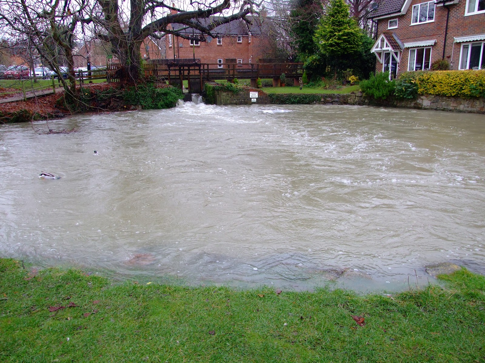
The view on the ground is somewhat different.

The upper Kennet looking upstream at Overton Bridge...

...and, turning to the right, the water spreading out to the back of The Bell pub on the A4.

The Kennet at George Bridge (also looking back upstream).

The EA river gauge at Pewsey Road Bridge in Marlborough reported levels at the upper limit of the Kennet's normal range this morning...

...but just downstream the water was lapping over at the back of Town Mill a couple of hours later.

Below Marlborough at Stitchcombe, locals are anticipating that the current levels flowing through the sluice weir...

...will raise the weir pool river to a height that may breach property (note the wall in the extreme right in image)...

...and are preparing for the worst.

Sunday, 18 November 2012

Access to the River Kennet at Arrowhead Road

Access to the Kennet at its confluence with Drapers Osier Bed Stream has been lost as the landowner has decided to restrict access to a short section of the north bank of the river. This will principally affect anglers who have long regarded this short 100m section as a place for "free barbel fishing". 

Access for paddlers downstream at Barbel Bar is unaffected, but for anyone who has found sufficiently high water levels to navigate Draper's Osier Bed Stream, the means to portage past the frequent tree fall strainers between the confluence with the main river and the weir is now reduced.

New signage at the start of Arrowhead Road...

...and further along at the start of the riverside path (to the right of the wheelie bin)...

...is reinforced by newly erected fencing.

The reasons for this decision are unknown, but the littering that has blighted this stretch of the bank cannot have helped in continuation of the former acceptance of public access.

The Kennet at the confluence with Drapers Osier Bed Stream has received little respect from a minority of the public.  This image is from 2010...

...this image is from the same location in 2011...

...whilst the same abuse was evident in this image from the waterside taken just over two weeks ago.

Paddlers have recently been receiving more attention in the press for their efforts to combine their love of rivers with longstanding efforts to contribute to their upkeep by such as organising voluntary clean up trips.  Recent examples of this practice include the rivers Dart and Tavy in Devon, whilst on the River Medway, the local canoe club joined forces with local residents in July 2012 for a joint clean up. 

Canoeists joined anglers to help with a "twelve week initiative to clear litter from the upper Wye" that was completed in May this year, and perhaps it is now time for paddlers and anglers to start working together along the River Kennet to ensure a similar pooling of skills for the benefit of all who are users of the waterways.

Many of the riverine stretches of the Kennet receive considerable attention and care from angling associations and landowners, but with the best will in the world, there are still places that would benefit from additional eyes and the ability to tackle debris from both the river and the bank.

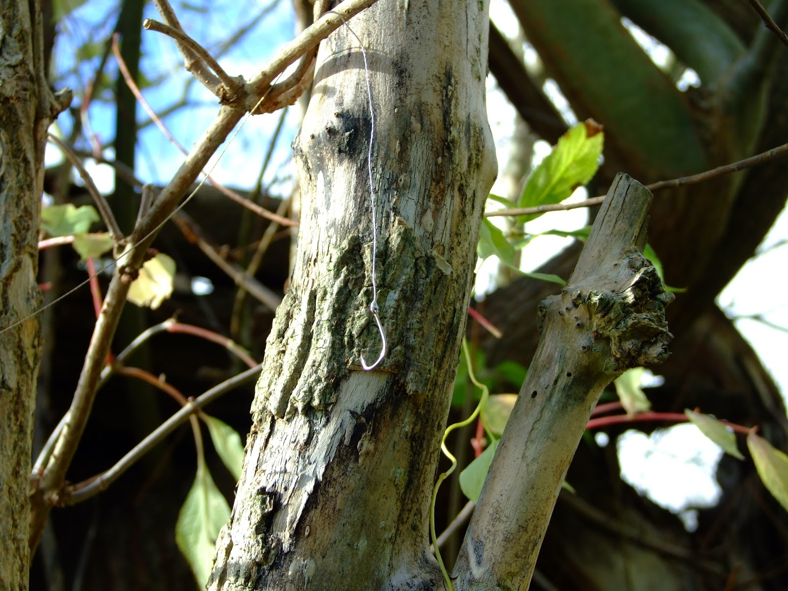
This hook and line was removed by a paddler from the Sulhamsted loop on 03.11.12...

...but this unintentional yet substantial snare for wildlife (click to enlarge and follow the bright threads to see just how much line is snagged; there was a family group of Long-tailed Tits, whose calls drew my initial attention, in the tree at the time), spotted in today's sunshine above Padworth Road bridge, was not so easily reached.  Perhaps an angler with loppers and a paddler to collect it from below would be the solution.

Sunday, 21 October 2012

River Access For All campaign launched


A quick re-writing of the currently popular WW2 poster theme serves to emphasise the point that canoeing and kayaking on the River Kennet is not an illegal activity.  If you are concerned that you might be challenged about your right to be paddling on the riverine Kennet, a new campaign has been launched to promote better understanding of the historical basis of all Public Rights of Navigation (PRONs) on inland waterways.

River Access For All has been created by "a group of ordinary canoeists who have formed a company limited by guarantee to promote the view that there is, and always has been, a public right of navigation on our rivers."


The campaign sets out basic historical evidence in support of PRONs, and shows how these have been undermined, leading to a position where

"There are several contradictory versions of the law claimed by the different parties. As a result canoeists and other river users who believe they have an unequivocal right to enjoy our rivers receive harassment and threats from those that believe they have a right to exclude them and keep rivers the exclusive domain of the privileged few.

This lack of clarity over the law means that, whilst those who wish rivers to be their exclusive preserve threaten legal action against those they label offenders, they can't follow through for fear of exposing the weakness of their case. In the absence of such a solution, harassment, verbal abuse and, on occasion, vandalism or violence, become the weapons of choice."


The River Access For All website sets out a basic challenge to those who hold views against a PRON in England and Wales: simply provide the evidence that a PRON does not exist.  Until such time as that proof is delivered, paddle on.

Sunday, 30 September 2012

Spotting Otters on the River Kennet

The chances are that unless you're paddling either very early in the morning or latter in the day as the nights close in, you're not going to see one, and even then it's unlikely you'll have the pleasure, but there are definitely Otters on the River Kennet once again.  Nobody really knows exactly how many might be in residence on the river and surrounding watercourses, but the fact that a sighting is still newsworthy ensures a steady stream of reports from a variety of sources.


Historically, the Otter (lutra lutra) will have been present on the Kennet for around 10,000 years, having recolonised the British Isles after the last glacial retreat.  It was certainly prolific enough in the valley to make itself the target of persecution by human hunting until relatively recent times, with the ban on Otter hunting being somewhat irrelevantly and far too belatedly introduced in 1978, long after the use of organochlorine pesticides had decimated the population in much of the UK between the mid-1950's and a nadir in the late 1970's.

An image of an Otter Hound Hunt at Brimpton Mill on the River Kennet reported in an 1885 edition of the "The Illustrated Sporting and Dramatic News".  One of the reasons given for occasional absences from Ramsbury school in the 19th Century was "boys following the otter hounds on the river Kennet". [Source: http://history.wiltshire.gov.uk/community/getschool.php?id=962]
 
Having disappeared in the SE of England by the early 1970's, the 1980's saw the start of natural recovery in Otter numbers and a slow spread back across England.  With low level supported reintroduction by conservation societies -
 
"The Otter Trust released 117 captive-bred otters between 1983 and 1999, mostly on East Anglian rivers, but with some elsewhere. Their last release was of 17 otters on the upper Thames catchment over a six-month period in 1999.
 
The Vincent Wildlife Trust released a further 49 rehabilitated animals (i.e. orphaned and injured wild otters kept in captivity until fit for release) between 1990 and 1996, many of these as part of a release programme in Yorkshire." [Source: "Otters - The Facts"]

- a now almost totally natural population of, possibly, several thousand Otters, has established itself across the country, including along the River Kennet.

It's difficult to judge exact numbers along the Kennet because the secretive and often nocturnal habits of Otters combined with their wide terrritorial ranging make accurate assessment extremely difficult. In the Fourth Otter Survey of England 2000-2002 it was noted that "No sites in this LEAP* area were positive but there have been sporadic, but unconfirmed, reports of otters on the catchment since 1994." *[A LEAP being a Local Environment Agency Plan].  However, at some point between 2002 and 2010 there was a dramatic improvement of the situation.


The Fifth Otter Survey of England 2009-2019 reported that, from a position of no confirmed evidence from 1977 to 2002, Otters had returned to the Kennet Valley in the ensuing 7-8 years

The 2009-10 report continued that "Otters appear to have re-colonised the Kennet since the last survey and are now present on all the main rivers in the western part of the area. No otter signs were found in the downstream, eastern, part of the catchment so it is possible that they reached this area from the Bristol Avon catchment to the west or the Hampshire Avon to the South. There was a positive site on the Kennet and Avon Canal near Burbage very close to the watershed between the Kennet and Hampshire Avon catchments. However there has been otter activity on the Kennet for some years and previous sporadic evidence of otters on the Thames at Reading where the Kennet joins it (G. Scholey,
pers. comm.). It is possible that otters have moved up the Kennet through the town. The lack of evidence on the lower Kennet is surprising."

The position on the Lower Kennet also now appears to be changing.  In 2011 anglers were reporting sightings in the "Aldermaston area", "a little further downstream @ (LB)wigmore lane" (the riverine loop at Sulhamstead), "padworth stretch of TAA" (the section of river running down from Padworth Mill to the Padworth Lane road bridge), "the Hambridge area", "at Brimpton", and "nr thatcham".  With further such reports of Otter sightings on the Lower Kennet as recently as August this year, the good news continues.

As above, the quieter riverine sections of the Kennet would appear to be the best locations for potential sightings, but in lieu of this watch out for
  • spraints (likely to contain American Signal Crayfish remains along the Kennet).
  • dismembered  crayfish remains (you may have disturbed an Otter's lunch if you find much left. Images from another local river here), partially eaten fish, and carefully opened birds eggs.
  • footprints on muddy banks.
A typical location for finding signs of Otters on Kennet riverine backwaters.


Monday, 27 August 2012

RDAA confirms Kennet anglers don't condone threats to paddlers

The Chairman of Reading and District Angling Association (RDAA) has provided a positive response to concerns raised over the language used in relation to canoeists and kayakers on the River Kennet by a small number of RDAA members.

Details of aggressive posts that have previously appeared on the RDAA forum in response to apparent confusion over questions regarding navigation by canoeists and kayakers were listed on the Song of The Paddle website forum two days ago, prompting one paddler (who is also an angler) to write to the RDAA Chairman, Alby Cohen.

Mr. Cohen has replied promptly with the statement

"Further to your recent e-mail - I can assure you we don't advise or condone the disruption of any water orientated activity, whoever the participant or whatever their hobby or sport.
Thank you for drawing the matter to my attention. I will endeavour to make our position clear on the forum and try to ensure the offensive material is not repeated.

We do, however, like to encourage open debate on our forum and regret when some take advantage. I'm confident that these threats are just that! Should any member be proven to have carried out such threats they would be severely dealt with by our disciplinary committee."


It is to be hoped that this position will provide a step towards greater mutual understanding of the differing needs of others by all legitimate and responsible river users on the Kennet.

Sunday, 5 August 2012

UK inland waterways access map expanded

In just over a year from the initial post reporting on the creation of a new map to record disputed river access in England and Wales, over a thousand sections of UK inland waterway have been recorded by paddlers to create the most comprehensive online listing of its type to date.

Disputed inland waterways are now marked in purple (it was felt that the red colour initially used might give the impression that paddling was not allowed on these sections).  A number of Scottish rivers have also been added by way of contrast to the situation in England and Wales.

The Access Map can be found in a dedicated section of the Canoe Days Out website, which itself provides details of several trips on the canalised sections of the Kennet Navigation and the Kennet and Avon Canal including the
  • Kennet Navigation, Berkshire, Aldermaston Wharf to Colthrop Lock
  • Kennet Navigation, Berkshire, Theale to Aldemaston Wharf
  • Kennet Navigation and Thames, Berkshire, Theale to Thames Valley Business Park, Reading
  • Kennet & Avon Canal, Wiltshire, Rowde to Barge Inn, Seend
  • Kennet & Avon Canal, Wiltshire, Devizes Wharf to Bishops Cannings Swing Bridge
  • Kennet & Avon Canal, Berkshire, Dunmill Lock, Near Hungerford to Newbury
  • Kennet & Avon Canal, Wiltshire, Honeystreet to Wooton Rivers
  • Kennet & Avon Canal, Wiltshire, Devizes to Honeystreet
  • Kennet & Avon Canal, Wiltshire, Wootton Rivers to Crofton Pumping Station
  • Kennet & Avon Canal, Wiltshire, Crofton Pumping Station to Hungerford
  • Kennet & Avon Canal, Somerset, Bathampton to Avoncliff Aqueduct

The Access Map homepage provides the option to view the map (with or without undisputed canal navigations), an alphabetical list of all the waterways logged, the ability to add further waterways, and a section of access-related links.
Due to the complicated inter-relationship of the River Kennet, the Kennet Navigation, and the riverine branches of these waterways, as well as the K&A Canal,...

The Access Map for River Kennet and Kennet Navigation now includes extended sections.  Please note that inclusion of a waterway does not imply automatic rights of access to that waterway or automatically confirm environmental conditions are appropriate for paddling at any given time.

...they are separately listed as follows:
  • Kennet & Avon Canal (from Newbury west) (#188): 90 kms
  • Kennet (Aldershot Water) (#172): 1 kms
  • Kennet (Benham Weir to Northcroft) (#67): 3 kms
  • Kennet (Bonsals Point to Garston Lock) (#178): 1 kms
  • Kennet (Burghfield Mill) (#179): 1 kms
  • Kennet (Chamberhouse Mill to Kings Bridge) (#169): 3 kms
  • Kennet (Crookham Manor to Brimpton Mill) (#170): 1 kms
  • Kennet (Drapers Osier Bed Stream) (#177): 1 kms
  • Kennet (Fobney Island river loop) (#181): 1 kms
  • Kennet (Frouds Marina corner to Ufton) (#173): 5 kms
  • Kennet (Ham Mill to Bulls Lock) (#68): 1 kms
  • Kennet (Hungerford to Hamstead Marshall) (#186): 9 kms
  • Kennet (Kings Bridge to Woolhampton) (#171): 2 kms
  • Kennet (Mildenhall to Hungerford) (#185): 16 kms
  • Kennet (Northcroft to the Navigation) (#182): 1 kms
  • Kennet (Padworth Stream) (#174): 1 kms
  • Kennet (Preshute to Mildenhall) (#184): 4 kms
  • Kennet (Southcote river loop) (#180): 1 kms
  • Kennet (Sulhamstead Weir loop) (#176): 1 kms
  • Kennet (The Craven Fishery) (#187): 1 kms
  • Kennet (Tyle Mill) (#175): 1 kms
  • Kennet (Upper reach) (#1143): 11 kms
  • Kennet (Widmead Weir to Chamberhouse Mill) (#69): 3 kms
  • Kennet Navigation (#65): 31 kms
Clicking on any of the above marked sections of waterway will generate a dialogue box from which a summary of reported access conditions can be viewed.

The dialogue box also permits paddlers to report access incidents or add new access ratings, as well as...

...the ability to view any existing reports.

Thursday, 2 August 2012

Black Swans on the upper River Kennet

Writing the previous post on non-indigenous species reminded me of a more positive recent alien close encounter on the River Kennet:
An Australian Black Swan at Axford on the upper River Kennet in late April 2012...

This species is not on the official list of birds recorded in Britain, but it is a category E species "recorded as introductions, human-assisted transportees or escapees from captivity, and whose breeding populations (if any) are thought not to be self-sustaining" and, furthermore, it is in the "E*"  grouping where "individuals are recorded as nesting with their own kind, and known or presumed to have originated from a captive origin."

There are concerns that it might out-compete native swans, which will no doubt call for someone to start culling them before long.

...one of a pair.  I've also seen them whilst paddling on the Itchen, when they seemed distinctly shy.

American Signal Crayfish biosecurity on the River Kennet

The fact that the River Kennet is literally crawling with  Pacifastacus leniusculus, the American Signal Crayfish (ASC),  is nothing new, with The Field belatedly reporting "Danger Signs" in 2008, whilst the same year The Telegraph produced the headline "American Signal Crayfish wrecks UK waters", nearly twenty years after their introduction to the UK.

In 2011 the Crayfish issues on the Kennet again came to national attention after British Waterways responded to "American crayfish destroying Britain's footpaths" in Newbury with protective reinforcement of the banks with polypropylene mesh.

Protection of the banks of the Kennet Navigation on limited sections of the river may provide limited local defence from tunneling erosion, but also serves to concentrate the damage elsewhere.

A number of fisheries have employed the services of trappers in an attempt to reduce the impact of crayfish predation and environmental damage...

Crayfish traps on the River Kennet Navigation (and elsewhere in the region - see this week's report from the Oxford Mail) are said to produce substantive hauls for their licenced users...

...which is evidenced in such as this half-dustbin catch of ASC from the Sulhamstead loop.

 ...but whilst a conversation with a trapper on the lower Kennet produced the comments that the average size of trapped ASC was falling and that fisheries were pleased with the effects of taking out the larger individuals which was resulting in the recruitment of improved numbers of smaller fish with the potential to grow to specimen size, this might not be acheiving much in terms of reducing overall ASC numbers.  ASC are cannibalistic, which means that as the larger specimens get caught more smaller crayfish survive, and so the total biomass of crayfish in the river may actually increase.

ASC are only one of the six non-indigenous crayfish species in the UK; details of Narrow-clawed, Spiny-cheek, Noble, Virile and Red swamp crayfish can be found at Buglife's UK Crayfish Website. Of the six invasive alien species, the Noble is only currently known in Somerset and Gloucestershire and does not out-compete our single native species, the White-clawed crayfish, Austropotamobius pallipes.  The Narrow-clawed crayfish is recorded more widely in SE England and has the potential to outcompete the White-claws, but, like the Noble, it is susceptible to the fungal crayfish plague, Aphanomyces astaci.  Whilst the Virile and Red swamp crayfish are only currently recorded in London, they are, together with the Spiny-cheek (also resident in SE England) and the ASC (interactive distribution map here), immune to and carriers of crayfish plague.

For paddlers on the River Kennet biosecurity measures to avoid spreading crayfish plague are simple:

Further information on wider biosecurity measures for paddlers can be found here and watch this:

Wednesday, 20 June 2012

Forward paddling from the BCU?

UPDATED POST:

See new comment at the end of this post.

The British Canoe Union (BCU) have released a new position statement on
"Access Arrangements for the shared use of non-tidal waters by manually powered craft", from which it appears that they might be about to finally stand up for the responsible use of English and Welsh rivers by recreational paddlers, which should include those who wish to canoe and kayak on the non-canalised sections of the River Kennet.
 Canoe England: Position Statement
Access Arrangements for the shared use of non-tidal waters by manually powered craft

1 Access to Water

Canoe England fundamentally believes in the principle for access to and along unregulated (1) non-tidal waters and does not subscribe to the present assumption by some for these waters to be deemed private. Recently published research contests this assumption (2).

Canoe England also takes a pragmatic view and believes that where Access Arrangements (3) are a means for shared use, they shall be on a joint local management basis that helps to protect the environment and respect the rights of other user interests.

The legal situation in England and environmental use of the waterways is detailed in the Canoe England Waterways and Environment Charter (4) and document “You, your canoe and the environment” (5).

From this position Canoe England will endeavour to:

1.1  Work constructively with partners, agencies, the local community, interest groups and the “Big Society” concept to support and develop the shared use of physically usable waters when environmental conditions (especially water levels) are suitable.

1.2  Develop acceptable management measures with partners to protect the environment and enable the wider use of waterways at all times as per the benchmark set by the Government access feasibility studies (2004): River Waveney - agreed minimum water levels, and no permit requirements; R Mersey – based on Dedication (6) for using waters.

1.3  Dispense with formal signed documentation, and for Access Arrangements’s (AA’s) to be based on statements/memorandums of understanding and/or Dedication.

1.4 Make these arrangements publicly available to all canoeists for self regulation.

1.5 Encourage canoeists to follow the guidelines of such arrangements.

1.6 Promote best environmental practice and responsible use and consideration for others on all waters.

Canoe England cannot regulate or police AA’s or grant access to any waters with or without an AA, and will advise canoeists to only canoe when conditions are suitable (5). The decision whether or not to canoe is the responsibility of the individual canoeist(s).

Canoe England acknowledges the different opinions on the legal position where public rights are not recognised. An AA shall be without prejudice to the views of the legal position of either Canoe England or the riparian owners and other interests. An AA shall neither confirm nor reject any party’s views or interpretation of the legal situation.

2 Public Rights

An AA shall not invalidate public rights to non-tidal waters physically usable by manually powered craft, to include canoes, should it be subsequently established:

2.1 Such rights have not been extinguished.

2.2 The historic use of usable waters is recognised to provide that right.

References

(1) Use of non-tidal waters

The position of public rights and the use of non-tidal waters in England are not straightforward:

Where there is an active Navigation Authority or where historic rights are recognised, rights are defined.

Where there is not an active Navigation Authority, waters are classified as unregulated and include abandoned navigations and other waterways on which there is a public right of navigation.

There is an assumption by some that many unregulated waters are private and use is resisted or shall be by way of a structured AA.

There is an overall lack of clarity for the shared use of non-tidal waters.

(2)  River Transport 1189-1600, February 2011; The Rev’d Dr Douglas Caffyn, www.caffynonrivers.co.uk

(3)  In the absence of a recognised public right to a waterway, the previous and present Government’s policy in England are for Voluntary Access Agreements (VAA’s). These can have conditions of use independently set by third parties, rather than being mutually agreed. Canoe England uses the terminology Access Arrangements (AA’s) rather than agreement.

Historically VAA’s are without rights, insecure, being subject to termination at short notice. When arranged, the periods of use imposed can be limited to a few days or weeks per annum and make some provision for those requiring a greater certainty of access at particular times. VAA’s are few in number due to the difficulties as highlighted by the Government sponsored demonstration access feasibility projects (2004). The project schemes on the Rivers Teme and Wear were unsuccessful.

The policy for VAA’s has been shown to have failed to meet an unmet demand when Canoe England has a remit to promote canoeing on all suitable waters in England. They may work well for some individuals or small organisations, however they cannot be used for securing public access.

(4)  Canoe England Waterways & Environment Charter –
http://www.canoe-england.org.uk/waterways-and-environment/policies/

The Charter takes into account the recently published research (2) that has established a strength of evidence for a historic public right of navigation to exist on all non-tidal waters that are physically usable. Canoe England believes the lack of certainty for public rights and the law has created tensions between user groups that can be resolved by a presumption in favour of a right of access; supported by appropriate local management measures.

(5)  You, your canoe and the environment -
www.canoe-england.org.uk/waterways-and-environment/environment

(6)  Dedication – leads to a public right of access. The Countryside & Rights of Way Act 2000 has provisions for Dedication by landowners and relaxing specific restrictions in the Act.


UPDATE:  If it all sounded too good to be true, and that the BCU/CE was actually going to start supporting recreational paddlers, their abysmal refusal to directly and publically respond to the access issues raised by concerned paddlers on the Canoe England Facebook page has given notice that the Access Position Statement is on par with John Nance Garner's opinion of the office of US Vice President.

With particular reference to clause1.4 of the above month-old CE Access Position Statement, and noting the level of Mushroom Management technique technique eminating from the Bingham Black Hole that is sadly indicated by this response to a paddler with a legitimate concern of widespread interest to recreational paddlers, the prognosis for it's survival with any degree of credibility is poor. 

Saturday, 12 May 2012

Government must do more for the River Kennet

The WWF has called on the Coalition Government to do more to address the drought conditions affecting many English rivers, including the River Kennet:

"As England’s drought restrictions come into force today, we believe the government must ramp up efforts to protect people and nature from drought – including introducing the widespread roll-out of water metering.
After two unusually dry winters, seven water companies - Southern Water, South East Water, Thames Water, Anglian Water, Sutton and East Surrey, Veolia Central and Veolia South East - have imposed hosepipe bans across large parts of the country, with most of England in or at high risk of drought. Although we’re urging the public to do all they can to save water, we’re also calling on the government and water companies to do far more.

We want them to lead the way and act with a sense of urgency to push for near universal water metering and to reform laws on how much water we take (abstract) from rivers - currently we take too much. Whilst abstraction reform is proposed by the government’s Water White Paper, a new law is unlikely until after the next general election. No plans for the roll-out of metering were made in the White Paper and no timetable, other than ad hoc improvements, have been put forward to tackle the issue. This is despite the government’s own estimated figures that the strategic roll-out of water metering could save the country £1.5 billion.

WWF’s freshwater expert, Dr Rose Timlett, said: “The government needs to be doing much more in response to the drought and should learn from the example of other countries. Parts of drought-stricken US and Australia are light years ahead of us, using a combination of water meters, rewards for water saving, efficiency kits and intermittent restrictions, to save up to 30% off water demand.

“Hosepipe bans are currently necessary, but they’re a quick fix and won’t solve the problems long-term. Unless the government does more and with a greater sense of urgency we might face the harsh consequences of losing unique wildlife in the not too distant future.”

How is the environment coping?
Water is the lifeblood of the river. When we have too little it affects everything in it - from the smallest bug to the biggest fish. At the moment rivers across the south and east are flowing below normal levels. Some are drying up completely, which can have immediate effects – fish get distressed and can suffocate, some plants and aquatic bugs that are the basis of the food chain die-off – and even when flows return it can take many years for the ecosystem to recover. Over time, low water levels can change the very nature of the ecosystem: fish spawning and migration are impacted, plant and bug populations change, the river can become choked with silt, and pollutants are more concentrated."


If you would like to help in protecting the future of the River Kennet contact your MP and ask him/her to

a) support a call for water metering as a national policy, and
b) stop the abstraction from the River Kennet by Thames Water for water use outside the Kennet catchment.

Whilst you are doing this why not also ask them to support your right to canoe and kayak on the River Kennet.

Your MP can be contacted as follows.

Claire Perry (Devizes)

Westminster:
House of Commons, London, SW1A 0AA
Tel: 020 7219 7050
Fax: 020 7219 1385

claire.perry.mp@parliament.uk
Constituency:
Renelec House, 46 New Park Street, Devizes, SN10 1DT
Tel: 01380 729358


Richard Benyon (Newbury)

Westminster:
House of Commons, London, SW1A 0AA
Tel: 020 7219 8319
Fax: 020 7219 4509

richard.benyon.mp@parliament.uk
Constituency
6 Cheap Street, Newbury, RG14 5DD
Tel: 01635 551070
Fax: 01635 569690

mp@richardbenyon.com

Alok Sharma (Reading West)

Westminster:
House of Commons, London, SW1A 0AA
Tel: 020 7219 7131
alok.sharma.mp@parliament.uk
Constituency:
16c Upton Road, Tilehurst, Reading, RG30 4BJ
Tel: 0118-941 3803

John Redwood (Wokingham)

Westminster:
House of Commons, London, SW1A 0AA
Tel: 020 7219 4205
Fax: 020 7219 0377
john.redwood.mp@parliament.uk
Constituency:
30 Rose Street, Wokingham, RG40 1XU
Tel: 0118-962 9501
Fax: 0118-962 9323
andrea.wca30@ntlbusiness.com

Rob Wilson (Reading East)

Westminster:
House of Commons, London, SW1A 0AA
Tel: 020 7219 2498, 020 7219 6519
Fax: 020 7219 0847
robwilsonmp@parliament.uk
Constituency:
12a South View Park, Marsack Street, Reading, RG4 5AF
Tel: 0118-375 9785
office@readingeastconservatives.com

Monday, 23 April 2012

Upper Kennet remains dry from Swallowhead to Lockeridge

A quick recce along the Upper Kennet yesterday revealed that the river remains dry from the traditionally cited source at Swallowhead Spring for approximately 6km (3.8 miles) to beyond Lockeridge.

This stretch would not normally be deep enough for paddling outside extraordinary conditions, but there's not even the chance of getting your toes wet at the moment, despite the relatively wet preceding week.

Looking back 'upstream' from below the Gunsite Road bridge, April-2012.

Looking back upstream from the road bridge into East Kennett, April 2012.

Looking back upstream from below the bridge near East Kennett Manor, April 2012.  This location (SU 119 676) was not pictured in the original list of locations from which the public can view the river in the Upper Kennet guide.

Looking downstream from above the footbridge at SU 125 680.  This spot was omitted in the original list of locations from which the public can view the river in the Upper Kennet guide.  Just walk down Frog Lane in Overton, heading north towards the A4.

As the river bed exits Lockeridge House the watercourse is currently dry... 

...but talking to a local lady resident I was assured water was flowing just a few hundred meters downstream.  She was, of course, correct, but what might look like a reasonable seasonal flow is actually an almost stagnant trickle.  The upper River Kennet is in serious trouble.